Research
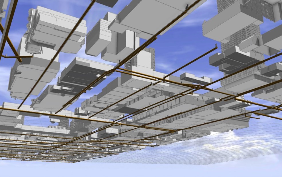
3D Modeling of Urban Underground Infrastructure (e.g., urban sewer systems as illustrated here)
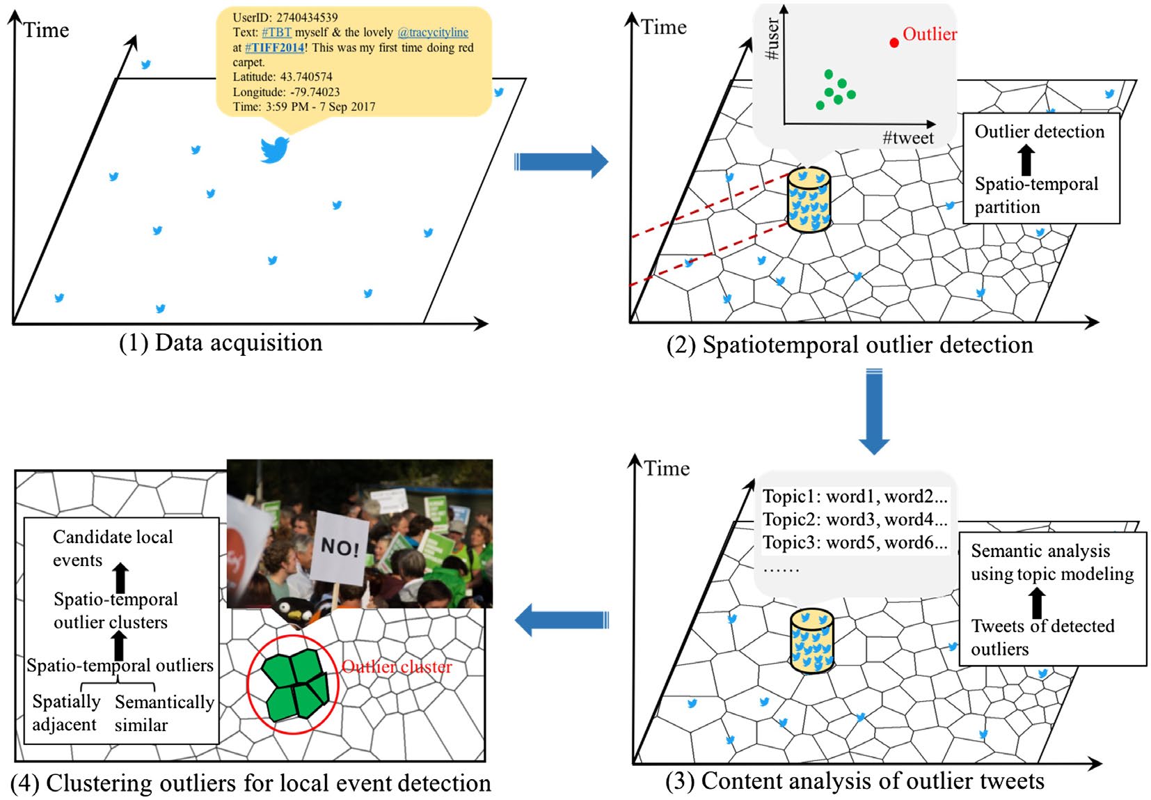
Spatio‐temporal distributions of the detected outliers in Toronto using Twitter data (source (external link, opens in new window) )
2019-2024, "Smart Campus Integrated Platform Development", Natural Science and Engineering Research Council (NSERC) Alliance Grant with support of FuseForward Solutions Group Ltd., total funding: $3,200,000, Co-PI with a share of $800,000 (PI: Prof. Jenn McArthur from Toronto Metropolitan University)
In collaboration with FuseForward Solutions Group, Toronto Metropolitan University researchers will develop an cloud-hosted Digital Twin (DT) for the Toronto Metropolitan University campus. This Digital Twin will serve as a simulation and visualization environment for all campus data, combining the campus buildings, supporting physical infrastructure, and mobility systems into a common interface. This will allow campus managers and other end-users to a) observe the current and historical behavior of the campus, b) identify irregular behavior or potential issues, and c) perform feasiblity and "what-if" analyses to test new campus strategies, such as emergency response, energy management, etc. The research outcomes are expected to be replicated to developing smart cities.
2019, "Machine-learning based big textual data analysis for job candidate resources extraction and matching", Natural Science and Engineering Research Council (NSERC) Engage Grant, Industrial Partner: WITS Consulting Inc., Principle Investigator.
2015-2018, "Developing a WebGIS Based Modelling Tool for Examining Cost Effectiveness of Best Management Practices in a Representative Agricultural Watershed", OMAFRA – U of G KTT Program, Project Team Member.
2014-2015, "3DSolar: Web-based 3D Environment for Modeling Urban Solar Energy Potential", Ontario Centres of Excellence (OCE) VIP, Industrial Partner: Woodstock Hydro, Principle Investigator.
2011-2017, "S&R GIS: An event-driven geospatial infrastructure for real-time decision support", Natural Science and Engineering Research Council (NSERC) Discovery Grant, Principle Investigator.
2013-2014, "High-Resolution 3D Mapping and Modeling of Solar Neighbourhood Potential", MiTACS Accelerate, Industrial Partner: S2E Technologies Inc., Intern: Annie Chow, Co-Supervisor.
2013, "Comparison of Solar Radiation Tools for Rooftops Solar Potential Analysis", Connect Canada Internship (Auto21 Inc. and Toronto Hydro – Electric System Ltd.), Intern: Freddy Paya, Academic Supervisor.
2012, Research Fellowship, Invitational Fellowships for Research in Japan Program, Japan Society for the Promotion of Science.
2012, "Development of a GeoConference Tool for Vigilance Projects", Research Contract with Quebec Ministry of Public Security, Principle Investigator.
2011-2014, "CanICE – A sea ice information database and web-based portal with novel, interactive knowledge discovery tools", Indian and Northern Affairs Canada: BREA Initiative, Co-Investigator (Project Lead: L. Braithwaite).
2011-2012, "Solar energy modeling and demonstration technology for urban buildings", Natural Science and Engineering Research Council (NSERC) Engage Grant, Industrial Partner: Woodstock Hydro, Principle Investigator.
2010-2011, "Updating Road Network using GPS Data Collected from Smart Phones", Natural Science and Engineering Research Council (NSERC) Engage Grant, Industrial Partner: GreenOwl Solutions, Principle Investigator.
2010, "Evaluating Solar Energy Potential Assessment and Mapping Methodology and Technologies", Toronto Metropolitan University: FEAS Dean’s Research Funds, Principle Investigator.
2009, Research Fellowship, Invitational Fellowships for Research in Japan Program, Japan Society for the Promotion of Science.
2005-2010, "Collaborative GIS for Municipal Planning: Enhancing Web-based Open GIS and Decision-making Tools", Natural Science and Engineering Research Council (NSERC) Discovery Grant, Principle Investigator.
2005-2010, “Development of a 3D predictive modeling platform for exploration, assessment & efficient management of mineral, petroleum & ground water resources", National Center of Excellence (NCE) GEOIDE: Research Projects, Co-Investigator (PI: Prof. J. Pouliot from Laval University).
2005-2007, "Geomatics technology: from data acquisition to contextual analysis", National Center of Excellence (NCE) GEOIDE: Research Projects, Co-Investigator (PI: Prof. M. Fortin from Lava University).
2004, "Spatial Information Management and Application Laboratory (SIMAL)", Canadian Foundation for Innovation (CFI) New Opportunity Fund, Principle Investigator.
2003-2005, "New Collaborative Geographic Visualization Methods and Tools for Right-of-Way Corridor Location", Natural Science and Engineering Research Council (NSERC) Discovery Grant, Principle Investigator.