Spatial Analysis and Digital Mapping in Environmental History
- Date
- April 16, 2025
- Time
- 3:30 PM EDT - 4:30 PM EDT
- Location
- Virtual
- Open To
- Open to All
- Website
- https://cdh.rula.info/newsletter/ (external link)
Please join us for the CDH’s final event of 2024-2025, a talk by Dr. Sean Keraj, Associate Professor of History and Vice-Provost, Academic, at TMU.
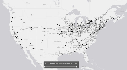
Sean describes his talk below: “Do you lack any and all digital mapping skills, but you wish you could make a map to better understand and present your research? That’s how things started for me and that’s when I turned to Web-based Geographic Information Systems (GIS) tools to map my historical research data. My textual primary sources contained spatial information that I needed to see on maps to better understand some of the work I was doing in environmental history. Environmental history examines the historical relationships between people and the rest of nature. Those relationships have spatial dimensions that I was able to analyze and illustrate using ArcGIS Online, a Web-based GIS tool.
In this presentation, I will deconstruct digital maps from two historical research projects. The first is a project on the history of livestock animals in nineteenth-century Canadian and US cities. The second is a study of the development of long-distance oil pipelines in Canada since 1947. I’ll show some of the ways I was able to translate my historical research data into maps and animations for analysis. I’ll also discuss the challenges and limitations of this research method.”
