About
Advancing Environmental Understanding Through Field and Spatial Science
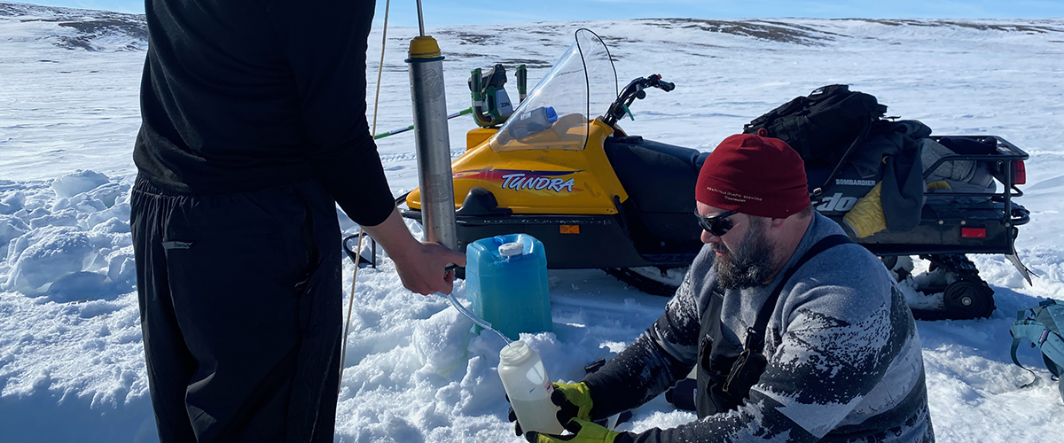
Sampling Lake Water on West Lake
The Polar Regions Spatial and Environmental Analysis Lab (PolarSEAL) focuses on understanding ecosystem change, landscape dynamics, and water systems in the Arctic and northern regions. Our research combines cutting-edge drone technologies (LiDAR, multispectral imaging), object-based image analysis (OBIA), and spatial modeling to map, monitor, and analyze changes in vegetation, terrain, and water quality.
A core component of our work is community-driven research with Indigenous partners, integrating traditional ecological knowledge with modern geospatial methods. Through participatory mapping and collaborative knowledge sharing methods , community members actively contribute to project design, data collection, and interpretation. This co-production approach builds local capacity, supports sustainable land management, and ensures that research outcomes are culturally relevant and actionable.
Our projects aim to document landscape change, ecosystem health, and climate impacts, while strengthening resilient food systems and conservation practices. By combining rigorous spatial science with ethical, community-led engagement, PolarSEAL develops insights that benefit both northern communities and global understanding of polar ecosystems.Research Focus / Expertise
PolarSEAL specializes in:
- Arctic and northern ecosystem monitoring: Mapping and analyzing vegetation, hydrology, and terrain changes over time.
- Drone-based mapping: Using LiDAR and multispectral sensors to create high-resolution 3D point clouds, digital surface models, and orthomosaics.
- Object-Based Image Analysis (OBIA): Classifying complex landscapes to detect ecological patterns and disturbances.
- Community-based participatory research: Integrating local knowledge with scientific data to inform conservation and management strategies.
Our research outputs support climate adaptation, conservation planning, and biodiversity monitoring across Canadian Arctic, Prairie Parkland, and sub-Arctic regions.
Community Partnerships
PolarSEAL collaborates closely with Indigenous communities to co-produce knowledge and build local research capacity. Our approach emphasizes:
- Participatory mapping of traditional land use and occupancy.
- Knowledge sharing workshops to document cultural and ecological insights.
- Community-led monitoring programs focused on water quality, wildlife, and landscape change.
Through these partnerships, community members actively shape research questions, methods, and interpretation of results, ensuring relevance, respect, and reciprocity.
Methodologies & Technologies
We integrate fieldwork and advanced spatial technologies to produce actionable insights:
- RPAS platforms equipped with LiDAR and multispectral sensors.
- High-resolution aerial imagery for vegetation, terrain, and hydrology analysis.
- GIS and OBIA workflows to segment and classify complex landscapes.
- Data integration from sensors, field observations, and community knowledge.
This multidisciplinary toolkit allows PolarSEAL to monitor ecological trends, detect early environmental changes, and support informed decision-making.
Impact & Goals
Our lab’s work supports:
- Environmental monitoring and conservation of ecologically and culturally significant lands.
- Climate adaptation strategies through accurate mapping of terrain, hydrology, and vegetation.
- Capacity building for students, northern community members, and Indigenous youth in applied geospatial and ecological research.
- Knowledge sharing to inform sustainable land management, policy, and education.
By combining cutting-edge technology with participatory approaches, PolarSEAL aims to produce research that is scientifically robust, culturally relevant, and actionable.
Team / People
PolarSEAL includes a dynamic team of graduate students, research assistants, and community-based researchers. Our team collaborates to collect, analyze, and interpret spatial and ecological data while fostering mentorship and skill development.
Opportunities / Get Involved
We welcome students, collaborators, and community partners to join PolarSEAL initiatives. Opportunities include:
- Fieldwork in northern ecosystems.
- Training in drone operation and geospatial analysis.
- Participatory research with Indigenous communities.
Learn more on our Opportunities page.
At PolarSEAL, our mission is to advance understanding of Canadian and Arctic ecosystems while fostering meaningful partnerships and building research capacity. By combining cutting-edge geospatial technologies, rigorous fieldwork, and community-led knowledge, we strive to produce insights that are both scientifically robust and culturally relevant. Our vision is a future where Arctic and sub-Arctic landscapes are sustainably managed, resilient to change, and valued for both their ecological importance and the communities that depend on them. Through collaboration, innovation, and stewardship, PolarSEAL is committed to supporting informed decisions, empowering communities, and training the next generation of environmental scientists.