Ontario Government Proposes Legislation That Could Unlock Development Potential Around Transit Stations in Ontario
By: Diana Petramala
May 3, 2019
In March, the Centre for Urban Research and Land Development (CUR) released a report highlighting how much space there was to build housing around Ontario’s major transit stations and lines. Yesterday, the Ontario Ministry of Municipal Affairs and Housing announced legislation that could help unlock some of that development potential.
The proposed legislation (Bill 108: More Homes, More Choice) announced by Ontario Ministry of Municipal Affairs and Housing aims to reduce the red tape and the costs associated with the process of residential development. In announcing the proposed legislation, the Province stated it wanted to positively impact housing supply by changing the regulatory framework in Ontario. With Bill 108, the government proposes giving the Minister of Municipal Affairs and Housing the authority to require a Community Planning Permits (CPP) System around major transit station and employment areas. (A major transit station area is defined as the area within 500 meters (or 800 meters as being proposed in amendments to the Ontario Places to Grow Act) of a planned or existing higher order transit station or stop.)
This policy commentary looks to define the community planning permit system and identify how this tool can help the Province achieve its minimum density target requirements around major transit stations as specified in its updated Growth Plan. We draw on work already done by CUR as well as perspectives gained from our recent seminar “Unlocking the Development Potential Along Ontario’s Transit Corridors”, available on our website.
Defining Community Planning Permit systems
CPPs are a planning tool that combines the individual zoning, site plan and minor variance processes in a predefined area and replaces it with a single application and approval process. The CPP allows a municipality to create a specific land-use plan around transit stations, without it being open to appeals by developers or third parties. We can best describe it as a secondary plan with teeth.
The CPP would fully outline such aspects as how much development will occur, the amenities desired for the area (for instance, parks and libraries), design requirements (building height, setbacks, housing mixes and so on), street features (such as pedestrian walkways, bike lanes, street sizes) and environmental and heritage protection guidelines, among many others, for the area covered by the CPP. Development in this area is then conditional on the provision of these amenities, services, design requirements and conservation policies.
The plan is developed with community consultations conducted upfront. Once the CPP is approved, development applications compliant with the design are automatically approved, thus reducing the development approval process to 45 days. In relation to this, the CPP cannot be appealed by a third party or developer. The developer can only bring applications to the LPAT if 1) a decision is not made by the municipality within 90 days or 2) the decision is not compliant with the CPP itself.
Municipalities currently have had the ability to use CPPs, but very few have applied them. Under the new legislation, the Ministry can mandate a CPP on municipalities for areas around major transit stations or employment areas. The municipality would still have considerable control over design requirements and conservation policies, but these would be subject to density requirements as set out by the Ministry.
The Provinces is also proposing that municipalities who use CPPs would have the right to take advantage of inclusionary zoning, allowing municipalities to ask for affordable housing as a condition to development within a CPP area.
Why is the Province looking to impose CPPs? To increase development around transit stations of course!
The Province is using CPPs to help speed up activity along transit corridors and to help boost supply of both market and below-market housing units.
The Ontario Places to Grow Act prioritizes transit-oriented-developments (TODs) – denser, mixed-used communities within 600 to 800 meters of a transit station, and LRT or bus stops. TODs help contribute to walkable/livable urban developments and reduce commute times for residents. TODs are also considered an integral part of economic development.
As such, the Ontario Places to Grow Act has set out density requirements for major transit station areas. Under the Growth Plan, municipalities are encouraged to achieve a minimum density of 200 people and jobs combined per hectare within 600 to 800 meters of a subway station, 160 meters for areas serviced by light rail (LRT) or rapid bus transit routes (BRT), and 150 meters for those around GO Train Stations.
However, many municipalities are behind on these targets. Data limitations for creating a measure of people and jobs per hectare is a challenge – although not impossible. We do, however, have data readily available to calculate the number of dwellings per hectare and persons per hectare within 800 meters of transit stations.
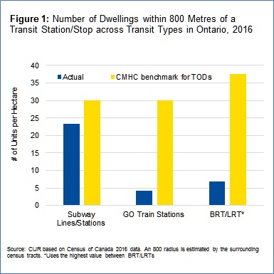
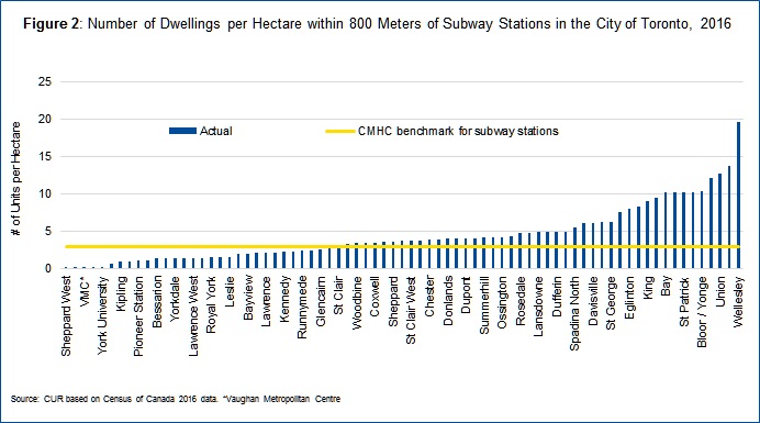
We can compare actual density around transit stations to the Ontario Growth Plan targets as well as estimated benchmarks for what makes a TOD successful, as they need enhanced density to make the transit financially viable and to attract the jobs and amenities (for instance coffee shops, restaurants and retail) that help make communities walkable and livable. Many studies have looked at the required density to make TODs successful. One such study was done by the Canadian Mortgage and Housing Corporation (CMHC), in which they found that successful TODs require roughly 30 to 37.5 dwellings per hectare, depending on the transit type.
Figures 1 and 2 show that the majority of transit nodes in Ontario are well behind on these targets. The most opportunity for growth exists around GO Train Stations and either existing or planned LRT and BRT lines where densities are only a fraction of what is needed to create vibrant TODs. However, many of Toronto’s subway stations also have low densities relative to TOD benchmarks and possibly even in relation to the requirements of the Ontario Places to Grow Act.
Nudging municipalities to follow through on the growth plan objectives related to TODs could make space to create millions of homes. Although market demand wouldn’t support the entirety of this development, the exercise illustrates that proper planning and zoning by-laws around major transit station areas can create room for a considerable amount of housing units – enough to accommodate all of the expected population and job growth forecast for Ontario through 2041.
How imposing CPPs will help unlock development
The Ontario government, then, wants to require CPPs to help speed up the development around major transit areas. This fits with the conclusions of a recent CUR seminar, “Unlocking Development Potential Along Ontario Transit Corridors” (available on our website), and suggests that CPPs could be helpful in unlocking the untapped development along Ontario’s major transit station areas.
CUR’s seminar included expert panelists Ed Sajecki (Mississauga), Amanda Kutler (Region of Waterloo), Robin Van de Lande (Ottawa), Jason Thorne (Hamilton) and Greg Tokarz (City of Toronto). These panelists all focused on factors they felt led to the creation of successful TODs. The first factor mentioned was the importance of a clear plan with goals and objectives regarding major transit station areas. Amanda Kutler from the Region of Waterloo noted that they planned everything from required intensification to infrastructure when proceeding with development plans. Robin van de Lande of Ottawa stressed the importance of having a plan for housing, as well as amenities, and of the need to use good quality urban design requirements to ensure TODs were walkable and livable.
The second factor they stressed was the need to quickly amend official plans and zoning by-laws to help achieve those objectives. Ottawa and Hamilton have both adopted transit oriented zones around major transit stations, called TOD zones in Ottawa and TOC in Hamilton respectively.
As Jason Thorne from Hamilton highlighted, the third factor which they often reiterated was the importance of stream-lining the development process and making it simpler for developers.
The results have been successful TOD developments. The Kitchener-Waterloo LRT has attracted a significant amount of residential and non-residential density. Housing construction doubled along this transit corridor in the period from 2016-2018 relative to activity in the prior six years. Ottawa has seen more activity around its LRT line than many subway stations in the City of Toronto in the last three years. Overall, Ottawa has reached average densities of up to 55 people and jobs per hectare around major transit stations along the LRT line, and it is aiming for an average density of up to 346 people and jobs per hectare.
In effect, CPPs will require municipalities to take into consideration all three of these factors identified by the panelists to encourage more development around major transit station areas. First, municipalities will need to set a clear plan for development around transit stations. Second, they will need to revise current zoning by-laws to comply with CPPs, effectively what can and cannot be built around major transit stations. Third, they will need to streamline the planning and development application process to comply with this mandate, thus reducing costs and shortening timelines.
Conclusion
Overall, the changes proposed in Bill 108 have the potential to help reduce costs, speed up development and increase the supply of both market and non-market housing. How they are implemented, however, will be key to the success in their use by the provincial government to achieve its objective of increasing the supply of affordable housing.
________________________________________________________________________
Diana Petramala is Senior Researcher at Toronto Metropolitan University’s Centre for Urban Research and Land Development (CUR) in Toronto.
_________________________________________________________________________________________________________