Cleanup and Smart-In-Up: A look at Ontario’s efforts to connect brownfields remediation, infill development and regional growth planning
By: Christopher De Sousa, PhD RPP, Professor, School of Urban and Regional Planning, Toronto Metropolitan University
September 6, 2018
Background and Summary
The Ontario Government has prioritized the redevelopment and intensification of brownfields (previously used and potentially contaminated lands) to accommodate urban growth in key strategic areas. This blog draws on three research studies to examine progress in the assessment, remediation, and redevelopment of brownfields in Ontario since late 2004, when the government updated the cleanup regime and started implementing urban intensification strategies.
Overall, the research finds that brownfield reuse activity has been rather extensive in scale, character, and value during the time periods examined, particularly in Toronto’s strong market. Notwithstanding the important barriers identified by the private sector, cleanup and planning policy seem to be working together. Dense redevelopment is occurring in areas identified by the provincial growth plan and by municipal Community Improvement Plans (CIP), thus aligning with the prime sustainability objective of growing in and up instead of out. Changing land use and increasing density in CIP and other locations seem to be key municipal tools for supporting brownfield reuse, although more can be done in terms of financial support and streamlining approvals, particularly in weaker markets and smaller cities surrounded by clean greenfields.
Highlights
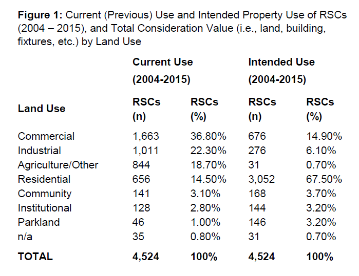
· 4,524 Records of Site Condition (RSC) covering 23,689 hectares of brownfields land (roughly the size of the city of Boston or Markham) were filed in Ontario from October 1, 2004 to December 31, 2015.
· Most brownfields were intended for conversion to Residential (67.5%) or Commercial (14.9%) use and had previously been used for Commercial (36.8%), Industrial (22.3%), and Agriculture/Other (18.7%) purposes.
· In Toronto, there are now 83,020 residential dwelling units (or 84,187 if units in “mixed” developments are included) on brownfields that were assessed/remediated between October 1, 2004 and June 30, 2011, with most being condominium apartments in central Toronto (53,286) and North York (15,319).
Key Findings - Research Study 1
This study examined the scale, character, and geographic scope of brownfields reclamation throughout Ontario between October 1, 2004 to December 31, 2015 using data from Records of Site Condition (RSC) completed by Qualified Professionals (Engineers and Geoscientists) and filed by property owners to Ontario’s Environmental Site Registry to verify that sites have been assessed and/or remediated to government standards (see Ontario’s Brownfields Redevelopment website for more detail (external link) ).
· Brownfields are proving to be a significant land resource for Ontario with 4,524 Records of Site Condition (RSC) covering 23,689 hectares of land.
· Most brownfields were intended for conversion to Residential (67.5%) or Commercial (14.9%) use, with the most common current (previous) use being Commercial (36.8%), Industrial (22.3%), and, interestingly, Agriculture/Other (18.7%) (Table 1).
· Nearly one quarter of brownfields reclaimed during the period only required a Phase 1 Environmental Site Assessment (ESA) involving the review of historical records and possible interviews/site visits to determine past use and potential risks from chemical processes, 69% conducted a Phase I and II ESA to generic standards (considers exposure risks safe for different land uses with residential/park standards being higher than industrial/commercial ones), and 7% employed site-specific, risk-based, approaches (considers risk of exposure associated with a particular project at a particular location).
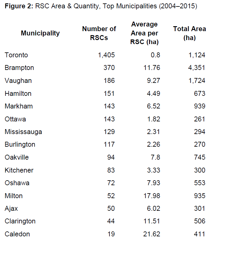
· Most brownfields have been reused in the urbanized Greater Toronto and Hamilton Area, and Ottawa region (3,275 RSCs) where property markets and growth planning have been strongest, and where land contamination is most likely due to historic use.
· While the city of Toronto filed more RSCs than any other municipality in Ontario (1,405 RSCs for 1,124 hectares, see Table 2), brownfields have also proven to be an important land resource for surrounding suburban municipalities where the total area reused is also high because the average site is larger (n.b., in some cases, as in Brampton, this is due to a greater share of filings being for larger former Agriculture/ Other sites.)
· Brownfields redevelopment is being embraced by the private sector with most (78%) brownfield RSCs filed between July 1, 2011 and December 31, 2014 (no data available for 2015) being owned by a Firm/Corporation/ Partnership or an Individual (6%), and few owned by Government (municipal 3.8%, provincial/ federal 1.7%, educational 0.2%)(10% no info, 0.5% other).
· Brownfields are unlocking significant value with those being transacted (80% of RSCs) recording a “total consideration value” (e.g., land, building, fixtures, chattels and other considerations) of $6.7 billion and paying $142 million in land transfer tax.
Key Findings: Research Study 2 (external link)
This study examined brownfield redevelopment activity in Toronto, Waterloo, and Kingston in greater detail using Records of Site Condition (RSC) filed between October 1, 2004 and June 30, 2011 and information about assessed value (land and buildings), building area, and tax class of property for 2013 from the Municipal Property Assessment Corporation. For Toronto, more detailed property information was gathered from public tax assessment terminals, property data maps, urban planning staff reports, market reports and development real estate websites to perform a more in-depth analysis of residential development. Also for Toronto, 2003 property tax assessments were gathered from the archives for a sample of 409 RSCs and compared with 2013 assessments to conduct a pre-post analysis of value increase.
City of Toronto
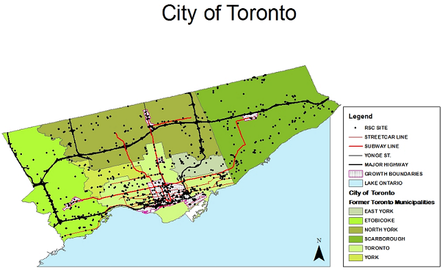
· While RSCs were filed for 927 hectares of brownfields (average of 0.9 ha per RSC), this resulted in the reuse and redevelopment of 1,161 hectares of property given that 31% of RSCs were filed for a portion of a property, while 69% were filed for the whole site. This is more than the land area of High Park (161 ha), the Toronto Islands (330 ha), and the Toronto Port Lands (356 ha) combined.
· RSCs filed in Toronto from 2004 to 2011 (n 1000) listed their current (previous) use as Commercial (46.9%), Industrial (25.0%), Residential (16.9%), Institutional (2.8%), Community (2.8%), Agricultural/Other (2.1%), and Parkland (1.4%) uses (2% n.a.), while their “intended” use was noted as Residential (66.2%), Commercial (12.1%), Community (6.8%), Parkland (4.8%), Industrial (4.3%), Institutional (3.7%), and Agricultural/Other (0.1%)(2% n.a.).
· A total of 86,843 units of all land use types were redeveloped on these sites, mainly in central Toronto (55,220) and North York (15,423) followed by Etobicoke (7,210), Scarborough (7,041), East York (1,142), and York (807).
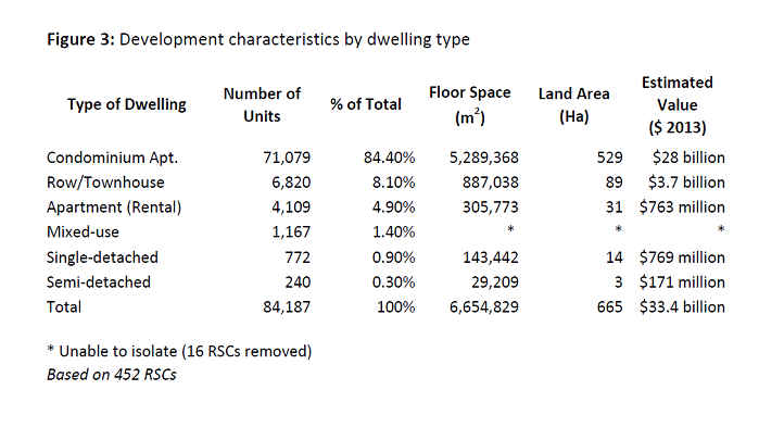
· Most units are residential dwellings (83,020; or 84,187 if residential units in “mixed” developments are included) located in central Toronto (53,286) followed by North York (15,319), Etobicoke (6,945), Scarborough (5,585), East York (1,113) and York (772) (Table 3 summarizes, by dwelling type, the number of units developed, floor space generated, land area reclaimed, and property value in 2013 dollars).
· It is estimated that 148,551 to 222,152 residents have been accommodated in the 83,020 dwelling units (low estimate based on average persons per household by dwelling type derived from a 2015 Toronto Planning report and high estimate based on Statistics Canada) and that dwelling units on brownfields represented about 60-70% of the total residential units developed based on City of Toronto (2016) estimates of 14,338 dwelling units completed per year on average from 2006–2015.
· The total assessed property value (2013) for all RSC properties was $37.1 billion dollars, with the greatest value in central Toronto ($22.7 billion) followed by North York ($6.6B), Scarborough ($4.7B), Etobicoke ($2.7B), York ($0.3B), and East York ($0.2B).
· A pre/post-RSC analysis comparing 2013 tax values to 2003 (pre-RSC) values adjusted to 2013 using an average annual inflation rate of 1.79% for 409 RSCs revealed that assessed value increased most in Toronto’s downtown core ($9.8B) over the period, followed by the inner suburbs (North York $2.2B, Scarborough $1.4B, Etobicoke $1.2B, York $0.2B, East York $0.1B).
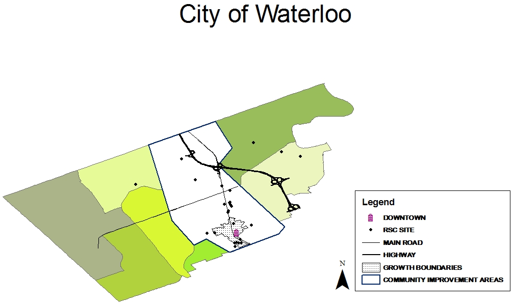
City of Waterloo
· 24 RSCs were filed for 15.5 hectares of brownfields, resulting in the reclamation and redevelopment of 29 properties (58 hectares).
· Based on RSC filings, most sites were currently (previously) Commercial (54%), Industrial (20.8%), or Residential (12.5%) (with 4.2% each for Community, Parkland, and Agricultural/Other), with the intended reuse listed as Residential (70.8%), Commercial (16.7%), Industrial (8.3%), and Community (4.2%).
· Property redevelopment based on assessments was still more mixed in terms of Residential 31%, Retail 24%, Office 14%, Industrial 14%, Vacant/Farm 14%, Other Commercial 10%, Industrial 7%.
· Total value of the redevelopment was assessed at $148 million (2013), with 58.5% of that being for residential projects and 20.7% in retail projects.
· Most brownfield land was being reclaimed within the city of Waterloo’s Community Improvement Plan (CIP) area, in the downtown core and along the central corridor (King Street).
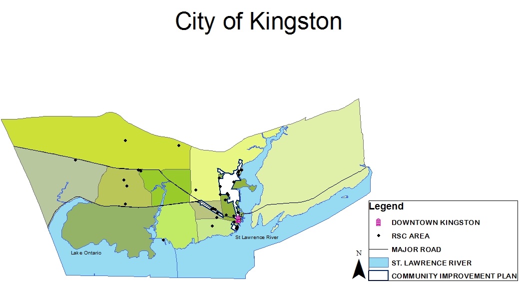
City of Kingston
· 45 brownfield RSCs were filed for 69.7 hectares of land, resulting in the reclamation and redevelopment of 38 properties (102 hectares).
· Most of the former brownfields based on RSC filings were used for Commercial (57.8%) followed by Industrial (17.8%), Residential (15.6%), Community (6.7%) and Institutional (2.2%) purposes, with the intended reuse listed as Residential (75.6%), Commercial (17.8%) and Institutional (6.7%).
· Property redevelopment from assessments was largely for Residential 58% purposes, followed by Retail 8%, Office 5%, Other Commercial 5%, Industrial 3%, Institutional 3%; 18% of assessed and remediated sites still remained Vacant.
· The 25 residential projects contained 1,350 units, of which 65% were multi-storey rental apartments, 17% condo apartments, 14% row/townhouse, and 3% single & semi-detached dwellings. Given that Kingston had 5,532 dwelling starts from 2005–2011 (790 per year) according to the Canadian Mortgage and Housing Corporation (2015), one can infer that dwellings on brownfields represented about 15-20% of the total.
· Total value of the redevelopment was assessed at $316 million (2015), with 67.9% of that in residential and 22.5% in retail projects.
· Most brownfield land was redeveloped within Kingston’s Community Improvement Plan (CIP) area (near the downtown core and in the inner suburbs along the main arterial Highway 2) and along the St. Lawrence River North.
Key Findings: (PDF file) Research Study 3
Using information gathered through interviews with twenty developers, landowners, and other private sector stakeholders in 2015, this working paper examined the motivations for, and barriers to, private sector redevelopment of brownfields in the Greater Toronto and Hamilton Area, as well as the perceived effectiveness of policies, programs, and tools that aim to foster redevelopment.
· Motivations: Private sector motivations have begun to focus more directly on real estate fundamentals (i.e., profit, market demand and location) and are less concerned with broader socio-economic and environmental objectives associated with brownfields cleanup and sustainability.
· Barriers: Major obstacles can be categorized as non-institutional and institutional.
· Non-Institutional barriers are customary complaints related to cost, liability, time, weak market demand, the degree or extent of contamination, and a lack of available funding.
· Institutional barriers present themselves at the provincial level (i.e., time for or complexity of site specific risk assessment, regulations not addressing site-by-site complexity, long duration of regulatory process, changes in regulations over time, mixed messages from different brownfield units within the Ministry of the Environment and Climate Change) and municipal level (i.e., limited municipal expertise on brownfields and complex development approval processes).
· Facilitation strategies: To enhance consistency in the application of regulations and improve the economic viability of projects, virtually all interviewees proposed changes to the regulatory process including: streamlining procedures, changing the government mandate from regulatory to partnership/facilitatory, and relaxing regulations. Many respondents also wanted to see more financial assistance, changes to the legal system, and greater municipal support.
· The overall perception was that the existing regulatory framework was well intended, but needed to be modified to make it more efficient, effective, secure, and generally more cognizant of the costs, timelines, and risks facing the private market. Many felt that the “easy” brownfield projects in strong GTHA markets have been redeveloped, so continued success in primary and secondary markets would require more collaboration to unlock both private and public returns.
Concluding Thoughts
Brownfields reuse in Ontario appears to be benefitting from both the province’s approach to assessment and remediation (which is similar to the voluntary cleanup programs used in the United States) and its' approach to planning which is considered more interventionist compared with the U.S. and most other provinces (i.e., setting population density targets for urban growth areas while municipalities allow market demand to protrude in those and in CIP areas supported on a project-by-project basis). That said, one can still look to the U.S. for ideas related to financial support and streamlining approvals and to European jurisdictions for brownfield planning and policy approaches that may be even more effective. England, for instance, has established national targets for development on brownfields, requires regional councils to assess land availability and identify brownfields suitable for housing and economic development, and makes local authorities generate and maintain public registers of brownfield land available for housing. So while the news in Ontario is generally good from a land cleanup, redevelopment, and sustainability perspective, the current state of our rapidly urbanizing province and planet obliges us not to rest on our laurels.
Next Steps: There are several ongoing brownfield research studies that I hope to report on in the near future, including research on municipal government issues and best practices in Ontario funded by the Social Sciences and Humanities Research Council of Canada (SSHRC) and research on the state of brownfields practice in Canada funded by MITACS and the Canadian Brownfields Network.
Acknowledgements: This private sector survey research was supported by Ryerson’s Centre for Urban Research and Land Development, while the RSC research was supported by SSHRC under grant number 435-2014-1790. I would like to thank the Ontario Ministry of Environment and Climate Change for providing some RSC data and my research assistants T. Spiess, S. Mah, N. Kohek, S. Marchese, J. Kuehnhold, P. Bam, K. Galinac, and J. Ramakrishnan.
References
· Canadian Mortgage and Housing Corporation. (2015). Housing now: Kingston Census Metropolitan Area. Ottawa: Queen’s Printer for Canada.
· City of Toronto. (2015). Housing occupancy trends 1996–2011. Toronto: City Planning Division, City of Toronto.
· City of Toronto. (2016). Profile Toronto: How does the city grow? Toronto: City Planning Division, City of Toronto.
· Research Study 1: De Sousa, C. & Speiss, T. (2018). The Management of Brownfields in Ontario: A Comprehensive Review of Remediation and Reuse Characteristics, Trends, and Outcomes, 2004-2015. Environmental Practice, 20(1), 4-15. https://www.tandfonline.com/doi/full/10.1080/14660466.2018.1407615 (external link)
· Research Study 2: De Sousa, C. (2017). Trying to Smart-In-Up and Cleanup Our Act by Linking Regional Growth Planning, Brownfields Remediation, and Urban Infill in Southern Ontario Cities. Urban Planning, 2(3), 5-17. https://www.cogitatiopress.com/urbanplanning/article/view/1026/1026 (external link)
· Research Study 3: De Sousa, C. (2015) Overcoming barriers and facilitating brownfields redevelopment in the GTHA: A review of results from interviews with private sector stakeholders. Report prepared for the Center for Urban Research and Land Development, Faculty of Community Services, Toronto Metropolitan University. Pg. 1-25 (PDF file) https://www.torontomu.ca/content/dam/cur/pdfs/WorkingPapers/CUR%20
(PDF file) Working%20Paper_Brownfields_Redevelopment_November%2023%2C% (PDF file) 202015.pdf
(PDF file) ________________________________________________________________________
Chris De Sousa is a professor at the School for Urban and Regional Planning at Toronto Metropolitan University in Toronto.